
Documenting Decay


The folly is basically a fanciful 'castle' built in the style of of a pele (or 'peel') tower, the traditional defensive homestead of the anglo/scottish border. Like most follies, various stories exist explaining why it was built. According to one account it was the work of a grieving widower, built so he could look across Bradfield Dale to the churchyard where his dear wife was buried. The truth is rather less romantic, for the fifty foot high tower was built in 1927 by Mr. Charles Boot, who lived nearby, simply to entertain his friends! The date is remarkable, this must be the most modern folly so far encountered in our travels.
Mr Boot used dressed stones and mullions cannibalised from demolished farms to build his belvedere. Inside, a wooden staircase wound round to a viewing platform. Local legend asserts that not too long ago a curious cow found its way into the tower, climbed the stairs and got hopelessly stuck! A rescue attempt then had to be launched to extricate the stricken animal. Perhaps it was to prevent a re-occurrence of this that the lower section of the internal staircase was removed. Consequently there is no longer any access to the viewing platform, which is sad.
There are some unanswered questions hereabouts. The tower stands in a green pasture obviously reclaimed from the moors, as the two large piles of stones on the hillside testify. But when was the field cleared? Even more intriguing are the massive fragments of decorated classical columns and bits of ornately sculpted masonry lying adjacent to the path, slumbering in the heather on this windswept hillside. What are we to make of them? Obviously great expense and labour was employed to get the materials to this remote spot. It seems unlikely that they were brought here simply to be left. Could it be perhaps that our friend Mr. Boot had designs on constructing another folly, a project which fate prevented from coming to fruition? We have already seen that Mr. Boot was in the habit of cannibalising older buildings to get the materials for his follies. Perhaps under other circumstances we would have been visiting not only Boot's Folly but 'Boot's Temple' also. And a final question:- where were the columns cannibalised from? they are probably 18th century in origin, and were perhaps associated with some stately home, or aristocratic stable block perhaps.
Peak dale church


The parish church cost £1,500 to build - of stone, in the "modern Gothic Style, consisting of a chancel and nave, and an unfinished western tower, containing one bell; an organ was provided in 1902, and there are sittings for 200 persons. In 1890 a burial ground of half an acre, granted by F.W. BAGSHAWE, esq. was consecrated by the Bishop of Southwell."Recent information is however that it has been declared unsafe, and it is now closed.


Good luck mine


cowdale lime works
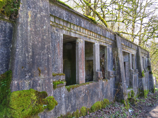
Just on the edge of buxton, overlooking the main road. I’ve driven past what must be hundreds of times but I’d never actually been up until today. I parked in a layby and walked about 100 yards to a gate and the first building is a neo-commumist-egyptian style admin block . The first structure you come to is the gatehouse clearly visible from the A6.Cowdale quarry was initially established in 1898 by the New Buxton Lime Co and listed as 'Staden Quarry'. The large stone-built kilns standing 50 foot high included a network of railway sidings above the A6. The four shaft kilns were taken over by the Buxton Lime Firms in 1908 and, shortly afterwards in 1909, three concrete buildings (the gate-house, power house and ancillary building) were built close to the A6 in a highly unusual 'neo-Egyptian' style.
The firm supplied high quality lime to Brunner Mond who finally bought BLF in 1918. In the mid-1920s concrete buttresses were added to the kilns shortly before the works were merged in 1927 to form I.C.I. Ltd. Quarrying ceased in 1948 but the works remained in operation until 1955 in order to store stone. In the latter part of the 20th century the tramlines were removed and some of the mine's buildings were demolished. The remaining works were left to slowly decay.
In 1997 English Heritage assessed the quarry as part of its 'Monument Protection Plan', concluding that the site contained 'very impressive remains'. In 2010 a development proposal by Buxton Water to use the site as a water bottling plant and for storage was tabled. It also included plans for the development of a heritage visitor's centre and heritage trail. This required the need for the establishment of improved road access and the subsequent demolition of the power house. The planning application was refused in June 2011 and again on appeal in September 2012. However the power house was demolished in controversial circumstances in May 2011


magpie mine


ballidon church

The unusual font may also date from this time. Octagonal in form, it is roughly carved with tracery, figures, fish, a bridled horse and several abstract motifs. Some of the carvings are clearly late medieval, while others appear to be Romanesque. Most peculiar, however, is that several of carvings appear to be upside-down! This has led to much speculation as to whether the font was fashioned from the base of a Saxon cross or perhaps the work of an apprentice…
Half-way up in to the west wall, there are the remains of a square fire-place. This clearly served a first-floor room, but all other traces of this have been lost. The church was restored in 1822 and all but rebuilt in 1882. The latter has left us with a Neo-Norman arch which leads up four steps to the chancel, where the east window by Kempe depicts the Resurrection.
The Commandment Boards and the Lord’s Prayer are, unusually, made from tiles. There are also some attractive, early 20th-century tiles depicting biblical scenes in the nave and chancel. The simple oak reredos has a hidden door which, when opened, reveals a miniature Romanesque arch with brightly painted zig-zag enclosing a simple crossThe last service in the church took place on 18 April 2003. see my youtube channel fir the video 👍👍


Abandoned tank


Old boiler high peak railway
Boiler for haulage fixed steam engine for hopton incline. high peak trail, wirksworth, derbyshire,


Anchor church

18th-century folly has been identified as one of the oldest intact domestic interiors ever found in the UK and was once, archaeologists tantalisingly believe, the home of an exiled Anglo-Saxon king.
In the 18th century, Anchor Church cave in south Derbyshire was used by local gentry as a place for parties, and until now it was officially understood that that was as far back as its history went.
But archaeologists now believe the cave house can be dated to 1,200 years ago, probably lived in by Eardwulf who was deposed as king of Northumbria in AD806 and died in AD830.